Aerial View2025-10-29T17:49:29-03:00

Aerial View Rendering Services.

SHOW YOUR ENTIRE VISION FROM ABOVE WITH AERIAL VIEW RENDERINGS

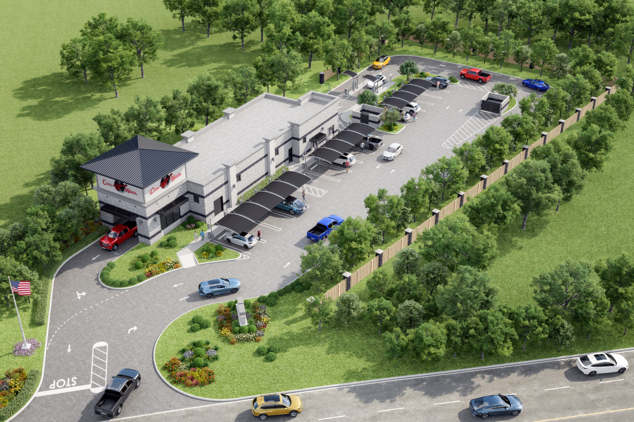
When it comes to presenting a property, nothing tells the full story like a high-quality Aerial View Rendering. From the sky, your project’s architecture, landscape, and surroundings come together to form one breathtaking image. At Xpress Rendering, we create photorealistic aerial renderings that help architects, developers, and realtors visualize large-scale projects before a single beam is set.

AERIAL VIEW RENDERINGS GALLERY

EXPERIENCE EVERY ANGLE OF YOUR PROJECT IN STUNNING DETAIL

Our portfolio showcases how Aerial View Renderings transform concepts into visually persuasive assets. These visuals are perfect for marketing campaigns, investor decks, and city approvals.

Whether you’re highlighting urban density, landscaping, or proximity to landmarks, we turn your plans into visuals that sell the vision long before building starts.

HOW AERIAL VIEW RENDERINGS ELEVATE ARCHITECTURAL VISUALIZATION

A well-crafted Aerial View Rendering isn’t just a pretty picture, it’s a strategic design tool. From above, every element of a project becomes clear: the relationship between buildings, the flow of roads, the surrounding landscape, and even how sunlight interacts with the site. This top-down perspective helps architects refine their layouts, developers market entire communities, and realtors showcase proximity to key amenities.

With Aerial Renderings, you can tell a complete story in one glance, one that captures the scale, location, and vision of your project. It’s the ideal way to communicate big ideas without overwhelming clients with technical drawings

THREE POWERFUL USES FOR AERIAL VIEW RENDERINGS

  • 1. Master Planning & Site Analysis
    See the full site layout and spatial relationships at a glance. Aerial View Renderings help visualize zoning, landscaping, and circulation in a clear, digestible format.
  • 2. Marketing & Investor Presentations
    Show potential buyers and investors the scale and beauty of your development. From large residential communities to mixed-use towers, Aerial Renderings evoke a powerful emotional connection by offering a comprehensive perspective of the overall project design.
  • 3. Design Approvals & City Submissions
    When it’s time for review boards or planning committees, an Aerial View Rendering makes complex proposals understandable, accelerating approvals and reducing back-and-forth.

CASE STUDY: SKYLINE DEVELOPMENT GROUP

Spacer line

When Skyline Development Group, a luxury property developer in the United States, approached us, they wanted to showcase the front façade and layout of their new mixed-use tower before breaking ground. Using detailed plans and site data, our team created a photorealistic aerial view rendering highlighting the project’s premium location and skyline integration. The visuals became the centerpiece of their marketing materials, helping them secure investors and pre-sales months before construction began.

This case is just one example, our Exterior Rendering Services are trusted by architects, realtors, developers, and designers across the U.S.

WHY CHOOSE XPRESS RENDERING FOR YOUR AERIAL VIEW RENDERINGS?

  • Architectural Accuracy You Can Trust:
    Every render is crafted by professionals with architectural backgrounds, ensuring scale, lighting, and perspective are precise.

  • Aerial View Expertise:
    We specialize in Aerial View Renderings that capture entire neighborhoods, landscapes, and urban environments with real-world context.
  • Tailored for Every Industry:
    Whether you’re an architect, developer, or real estate marketer, our renders communicate your vision with clarity and beauty.
  • Customizable Views:
    From low-altitude drone-style shots to panoramic master plan perspectives, we adapt the camera angle and style to your project goals.
  • Marketing-Ready Results:
    Our images are optimized for websites, brochures, billboards, and digital listings, helping you stand out instantly.
  • Fast Communication, On-Time Delivery:
    With Xpress Rendering, you’ll experience seamless communication, quick feedback loops, and on-schedule delivery.

TESTIMONIALS

Spacer line

Dennis D.

Architectural Design Services

“My experience with Xpress Rendering was excellent. The level of communication is something I wish I had in all facets of my business. “

Nick H.

Architectural Design Services

“Extremely professional, quick turn-around, great communication and affordable pricing! Couldn’t ask for more!”

Victoria R.

Architectural Design Services

“Their responsiveness from the very beginning was great. Communication and understanding was extremely easy and quick!”

Frequently Asked Questions (FAQs)

1. What are Aerial View Renderings?2025-10-22T14:06:14-03:00

Aerial View Renderings are 3D visualizations that show your project from an elevated or top-down perspective. They provide a comprehensive view of the architecture, landscaping, and surrounding area, perfect for large-scale developments or master plans.

2. Why are Aerial Renderings important in architecture?2025-10-22T14:07:04-03:00

They allow architects, developers, and realtors to present the full context of a design, helping viewers understand layout, environment, and scale more effectively than ground-level images.

3. How are Aerial View Renderings created?2025-10-22T14:07:38-03:00

Our process involves 3D modeling, applying textures and materials, and setting up realistic aerial lighting. We then fine-tune perspective and post-production to achieve a natural, photorealistic look.

4. What’s the difference between aerial photography and aerial rendering?2025-10-22T14:08:10-03:00

Aerial photography shows real-world images captured by drones or aircraft. In contrast, Aerial renderings visualize future or conceptual designs within a site-offering a realistic preview even before construction begins.

5. Who benefits most from Aerial View Renderings?2025-10-22T14:08:43-03:00

Architects, developers, realtors, and home builders use aerial visuals to present site layouts, building clusters, and urban integration in their proposals and marketing.

6. Can you include surrounding context like streets, parks, or landmarks?2025-10-22T14:09:23-03:00

Yes. We often incorporate full city blocks, green areas, and recognizable landmarks to enhance realism and convey location advantages.

7. What files do I need to start an Aerial View Rendering?2025-10-22T14:09:54-03:00

You can share CAD drawings, site plans, PDFs, or sketches. The more detailed your files, the more precise and realistic the final rendering will be.

8. How long does it take to complete an Aerial Rendering?2025-10-22T14:10:26-03:00

Delivery time depends on the project’s scale, but most Aerial View Renderings are delivered within 5 to 10 business days.

9. Do you offer revisions if I need adjustments?2025-10-22T14:10:53-03:00

Absolutely. We include feedback rounds to ensure your final aerial rendering matches your exact vision.

10. Can Aerial View Renderings be used in Virtual Reality Tours?2025-10-22T14:11:19-03:00

Yes! We can integrate your Aerial View Rendering into VR360 Virtual Tours, allowing clients to explore your project from multiple angles interactively.

Start My Project

Emails
24/7

Follow us on Social Media

Xpress Rendering

Houzz Logo

Subscribe to the Xpress
Newsletter

And get 10% OFF

    Not valid whit any other discount. Terms and conditions and the privacy policy

    Go to Top